In Peru’s Amazon, deforestation and crime sweep through Indigenous communities
Nov 6, 2021 / Mongabay / Story by Genevieve Belmaker
- Mongabay Latam investigated the territorial security of Indigenous communities in five regions of the Peruvian Amazon: Loreto, Ucayali, Pasco, Huánuco, and Madre de Dios.
- A geospatial analysis of deforestation, illegal mining, and illicit coca crops in these five regions shows that 1,247 Indigenous communities have been affected.
- The study also revealed that 647 self-identified Indigenous communities in these five regions do not have official recognition from regional authorities to certify their existence and therefore obtain legal title to the land.
Peru is home to many Indigenous communities that don’t appear on official maps. Without government recognition, these communities’ existence rests solely on their community names and on the knowledge of the federations that represent them. This is the case for the community of Manco Cápac, in the Loreto region, in existence for 70 years but without any documentation that can attest to it. Its inhabitants know by heart where their community’s land begins and ends.
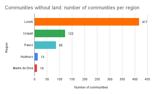
In the Loreto region alone, there are 417 self-identified Indigenous communities that do not have the recognition of regional authorities to certify their existence. The same issue exists in other Peruvian regions, too: Ucayali has 122, Pasco has 85, Huánuco has 13, and Madre de Dios has 10 communities that are not officially recognized. This makes a total of 647 unrecognized Indigenous communities in five regions of the Peruvian Amazon.
However, these communities’ main problem is not just their lack of government recognition. When the more than 2,000 Indigenous communities in Peru — the recognized, unrecognized, and those in the process of recognition — are marked on a map, they often overlap with areas affected within the past 10 years by deforestation, illegal mining, and illicit coca crops.
Mongabay Latam conducted an analysis on the impact of environmental crimes on Indigenous territories. In these five Amazonian regions, the analysis found that at least 1,247 Indigenous communities are affected by illegal mining, illicit crops, or deforestation.

Recent photography shows the communities surrounded by illegal mines that pollute their rivers with mercury; by invading loggers targeting rainforest timber; and by violent drug traffickers. Of the 54 clandestine airstrips detected by the Ucayali regional government, typically associated with traffickers, 15 are within Indigenous territories. Seven of the 10 environmental defenders murdered in the last year and a half are Indigenous Amazonian leaders. All seven were shot dead in incidents that their communities have linked to invaders and drug traffickers.
Six months ago, a team of journalists from Mongabay Latam began compiling information from civil society organizations and from the government to analyze the incidence of environmental crimes in Indigenous communities. The team analyzed data on the legal ownership of Indigenous lands, the advance of deforestation, and the locations of coca crops and illegal mining camps in the regions of Huánuco, Ucayali, Loreto, Pasco, and Madre de Dios. The Mongabay Latam team then visited the communities where the data suggested the situation was most dire.
See the database here: Indigenous communities and environmental crimes in Peru
‘Ghost’ communities
The first challenge that Indigenous communities in Peru face is having to “certify” their own existence. Their vulnerability lies in the government’s difficulty in recognizing, titling, and registering them in official records. Public entities often show different data in terms of the number of recognized communities. “It is impossible to arrive at an exact figure,” said Katherine Sánchez, a legal specialist at the Peruvian Society for Environmental Law.
Unrecognized communities have less legal security. “Communal property, when it is not recognized, has limitations for managing projects and social programs, including public services such as health care centers,” said Nelly Aedo, director of the Indigenous communities program at the Ombudsman’s Office.

This lack of protection is reflected in the name these communities receive in the Ministry of Culture’s database: “Locality without type identified by the DRA [Regional Directorate of Agriculture],” almost as if they’re “ghost” communities. The recognition of a native community is the first step to obtaining legal security — that is, to getting a title for the communal territory.
“If you are born Indigenous, you automatically have a right to the collective territory and to recognition as Indigenous people. As a consequence, what pertains to the government is to recognize that right,” said Ernesto Ráez, executive director of the Common Good Institute (IBC, or Instituto del Bien Común in Spanish). For more than 20 years, IBC has worked with Indigenous communities in land use planning and environmental conservation.
Manco Cápac is one of the more than 647 communities in the regions of Ucayali, Loreto, Huánuco, Pasco, and Madre de Dios that are awaiting recognition and the right to officially titled territory.
“There are several communities to recognize. Five or 10 years ago, the communities on the banks of the Amazon River said that they were campesino communities, and only with time have they been identifying as Indigenous communities,” said Manuel Ramírez, the president of the Indigenous People’s Regional Organization of the Eastern Amazon (ORPIO).
This was an issue of discrimination, Ramírez said, because they felt they would have more rights as a campesino community, but only later realized that this wasn’t the case. “Now they are recognized, but they are not all part of a federation; if you are not in a federation, you do not have the benefits of the titling projects,” Ramírez said.

In Mongabay Latam’s database, which holds information from official institutions and civil society organizations in Spanish, 1,140 communities in the five regions are listed as titled. The majority of these titled communities, 742, are in Loreto. The rest are in Ucayali (255), Pasco (105), Madre de Dios (27), and Huánuco (11).
Deforestation, drug trafficking, and violence
In April 2020, soon after the beginning of the COVID-19 pandemic, the murder of Arbildo Meléndez marked the beginning of the violence that would erupt in the coming months. Meléndez was the president of the Indigenous community of Unipacuyacu, made up of members of the Kakataibo ethnic group in Huánuco.
Four Kakataibo leaders and three Ashaninka leaders have been murdered so far this year. Kakataibo lands, in both the Ucayali and Huánuco regions, have become the most critical areas in terms of the presence of illegal activities, especially drug trafficking.
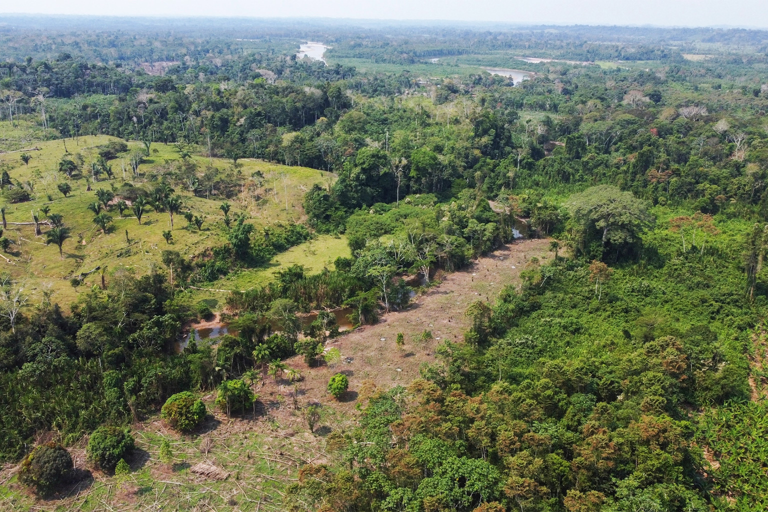
Between 2017 and 2019, five Indigenous communities in Huánuco — Santa Martha, Nuevo Unidos Tahuantinsuyo, Unipacuyacu, Tsirotzire, and Santa Teresa — lost 16,052 hectares (39,665 acres) to deforestation.

Mongabay Latam journalists were able to enter Unipacuyacu very briefly. They saw the devastation in the area and used a drone to capture images of what is believed to be a clandestine airstrip. Inhabitants of the community say they live in fear.
Indigenous communities across Ucayali face a similar scenario. According to the analysis, there are at least 16 Indigenous communities under the threat of deforestation caused by drug trafficking. Between 2017 and 2019, 35,525 hectares (87,784 acres) have been affected.
Data from 2020 may paint an even direr scene, as Peru lost more forest area last year than in the past 20 years. “It is scandalous,” IBC’s Ráez said of the increased deforestation in Peru, which exceeded the 2019 rate by 50,000 hectares (nearly 124,000 acres). “If we abandon the monitoring of the Amazonian biome, then the defenders of those forests, who are from Indigenous communities, are left unprotected,” Ráez said.
“During the pandemic, illegality has increased a lot, because while we were obedient and did not go anywhere, the criminals continued to advance,” said Berlin Diques, president of the Ucayali branch of the Interethnic Association for the Development of the Peruvian Rainforest (AIDESEP).
The Ministry of Environment, in a written response to Mongabay Latam’s inquiries, said that “the regions where the greatest increase in deforestation has been identified during 2020 have been Ucayali, Loreto, and Madre de Dios, compared to 2019. The drivers have been diverse. For example, in Ucayali, an increase in coca crops has been identified in some provinces, such as in Coronel Portillo.”
The ministry also confirmed that “the Indigenous communities have perhaps been the most affected by deforestation problems in 2020. They have been more exposed and more vulnerable to several informal and illegal agents who — because of the retraction of control mechanisms due to the COVID-19 pandemic — have taken advantage of this situation.”
Community resistance
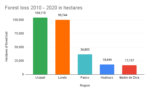
The analysis of the deforestation in the five Peruvian regions showed that around 276,000 hectares (about 682,000 acres) of forest were lost within Indigenous territories in the last 10 years.

In Ucayali alone, 344 Indigenous communities have lost 104,000 hectares (about 257,000 acres) of forest in the last 10 years. Authorities from Ucayali’s regional government have also detected 54 clandestine airstrips in the region. Thirteen are in Indigenous communities and two are in Indigenous reserves.

Atalaya is home to the largest number of Indigenous communities in Ucayali, around 300, and is the most affected by forest loss in the region. Many communities in Atalaya serve as buffers for protected areas like El Sira Communal Reserve.
“Communal property, when it is not recognized, has limitations for managing projects and social programs, including public services such as healthcare centers.”
Nelly Aedo
Director of the Indigenous communities program at the Ombudsman’s Office
The stories of resistance are visible on Mongabay Latam’s visualization map. Indigenous territories surrounded by deforestation appear, and many of their residents have organized to defend their land. But these acts of resistance have become increasingly dangerous for them.
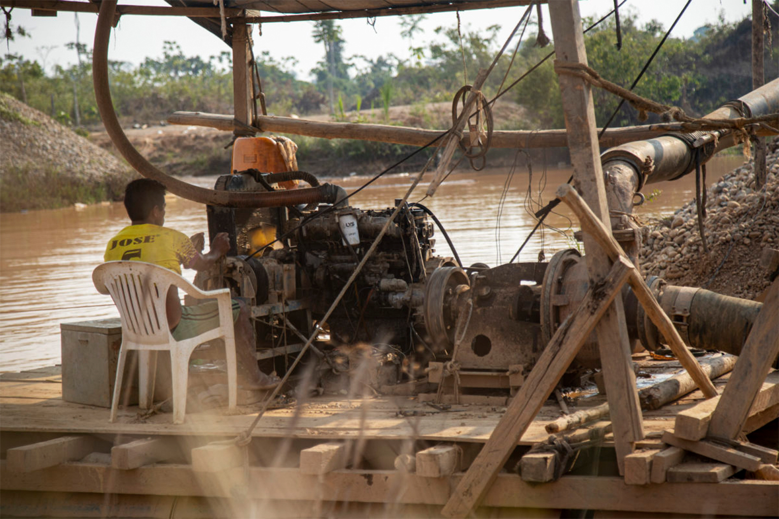
The threat of illegal mining
In other regions, like Madre de Dios, it’s possible to see the effects of another serious environmental crime: illegal mining. Reporters from Mongabay Latam traveled through San José de Karene, a community in Madre de Dios which does have an official title, and where the impact of illegal mining was evident. According to the analysis, illegal mining has stolen 6,282 hectares (15,523 acres) of forest from the community.
“Today, customs are no longer practiced,” said Francis Quique, a member of the San José de Karene governing board. “Even parents themselves do not handle this knowledge, and this is being lost due to mining.
“If we lose our customs,” he added, “then it would not even make sense to call ourselves an Indigenous community.”
According to the analysis by Mongabay Latam, despite all the efforts by the communities to tackle the issue, illegal mining has impacted 129 communities in the five regions in the study.
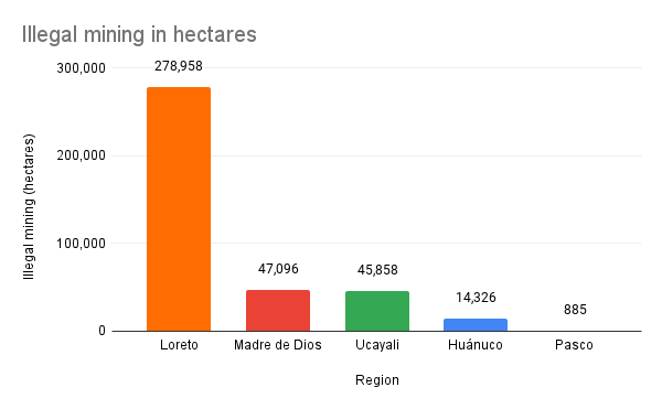
Of the five regions in the study, Madre de Dios experienced the largest percentage of land lost to illegal mining, with a total of 47,096 hectares (116,377 acres) between 2013 and 2020.
Loreto is the region with the greatest number of communities affected by illegal mining: 84 in total. The affected land spans 278,958 hectares (689,320 acres) belonging to Indigenous communities.
These communities also must grapple with the lack of georeferencing and clearly defined boundaries for their territories. This allows outsiders to invade and later legalize the occupied territory. This has been the case in Catoteni and San José de Karene.
“If you are born Indigenous, you automatically have a right to the collective territory and to recognition as Indigenous people. As a consequence, what pertains to the government is to recognize that right,”
Ernesto Ráez
Executive director of the Common Good Institute
Sánchez, from the Peruvian Society for Environmental Law, said that “georeferencing reliably determines the limits of a community” and that having this information requires “a specific procedure just as demanding as titling. However, it is necessary to execute it to avoid overlapping and border conflicts.”

“What would correspond would be to grant large territories to the communities. But we have communities that are absurdly small, that cannot be sustained economically, and that have been condemned in this way to poverty, human misery, and environmental degradation,” said IBC’s Ráez.
Mongabay Latam requested an interview with the Ministry of Culture to ask about the process of titling these Indigenous communities and about their vulnerability to illegal activities. The ministry declined an interview and said the issues fell outside of its purview. Mongabay Latam then contacted the Ministry of Agricultural Development and Irrigation, the entity responsible for titling rural lands, but this ministry also declined an interview.
Obstacles and opportunities
Since 2013, the Ministry of Agricultural Development and Irrigation has overseen some legal matters for the land in rural and Indigenous communities, according to a report by the Ombudsman’s Office. However, some administrative procedures are handled by the regional governments.

In June 2021, an addendum was signed for a joint declaration between Peru, Norway, and Germany that seeks to reduce greenhouse gases from the deforestation and degradation of forests in the Amazon. The declaration’s goal is the legalization of at least 5 million hectares (more than 12 million acres) of Indigenous land, a process that includes demarcating the territories and granting property titles. Titling land is a first step for communities to be able to access the REDD+ (reducing emissions from deforestation and forest degradation) mechanism, which may allow Indigenous communities to access funds to help keep their forests standing.
However, the data from Mongabay Latam’s analysis paint a grim picture. Without clear protective measures from the government, the outlook for the Indigenous communities in the Amazon is increasingly complicated.

General editing: Alexa Vélez, Thelma Gómez, and María Isabel Torres.
Investigation: Yvette Sierra.
Project coordination: Vanessa Romo.
Reporters: Cristina Fernández, Daniel Carbajal, Fiorella Fiestas, Vanessa Romo, and Douglas Tangoa.
Data visualization: Diego Arce, Rigoberto Carvajal, Sairo Alemán, and Jairo Peña of the Latin American Center for Investigative Journalism (CLIP).
Spatial analysis: Juan Julca.
Video and photography: Christian Ugarte, Vico Méndez, and Roberto Wong.
Audiences and networks: Dalia Medina and Alejandra Olguín.
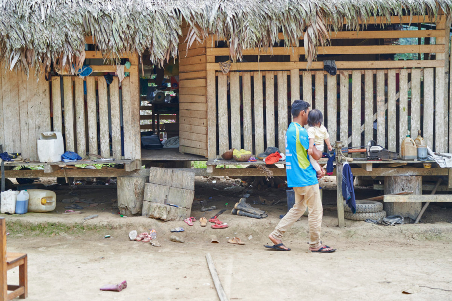
Banner image: A resident of Unipacuyacu in Huánuco. Image by Christian Ugarte.
This story was reported by Mongabay’s Latam team and first published here on our Latam site on Sept. 30, 2021.