Indigenous Bolivians take the defense of their land into their own hands
Oct 26, 2021
- Indigenous community members in Bolivia’s Lomerío region are volunteering to serve as socioenvironmental members in a bid to protect their territory.
- They’re tasked with confirming satellite information identifying the location of potential fires, guarding against illegal mining and oil and gas extraction, and invasions of their land.
- Around 50 monitors from four Indigenous territories are participating in the program, which they call “an incredible experience.”
When the threats of potential mining activity arrived in the Bolivian community of Las Mangas, in the Indigenous Lomerío territory, the community held a meeting where they decided to put a stop to mining. Ailin Vaca Diez, the leader of the community, took a stand. “I wanted to make it clear that, for the sake of a few pesos, we were going to lose our flora and fauna,” she says.
In 2018, in recognition of her efforts to protect her communal territory, Vaca Diez was asked to join a group of socioenvironmental monitors that work with the Center for Autonomous Territorial Planning (CPTA), an initiative set up by the Center for Legal Studies and Social Research (CEJIS), an NGO.
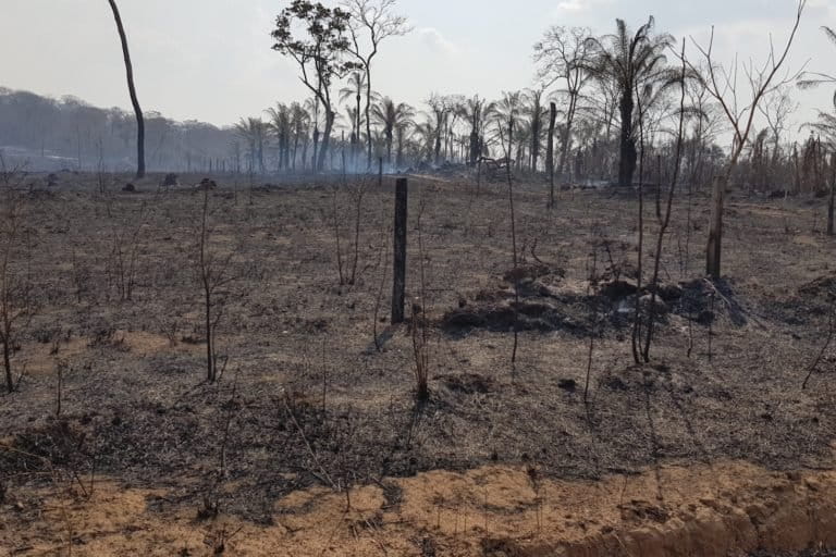
In recent months, this group of 50 monitors has played a vital role in tackling fires. As the fire season approaches, the team remains on alert for any risk to their territory. But they have other responsibilities, too.
As guardians of their territories, the monitors are also attuned to any possible mining and oil and gas exploration activities in their forests, as well as the threat of droughts that could affect lakes and rivers. In addition, they receive ongoing training in how to apply Bolivian environmental law so they have accurate information when the time comes to defend their land.
Technology in Indigenous territories
Lomerío, located in central Bolivia, is one of four Indigenous territories to have engaged socioenvironmental monitors.
In these Indigenous areas, the monitors have become key allies to the satellite monitoring that CEJIS already does. They verify on the ground what the satellite images pick up, including hot spot alerts that could develop into fires.
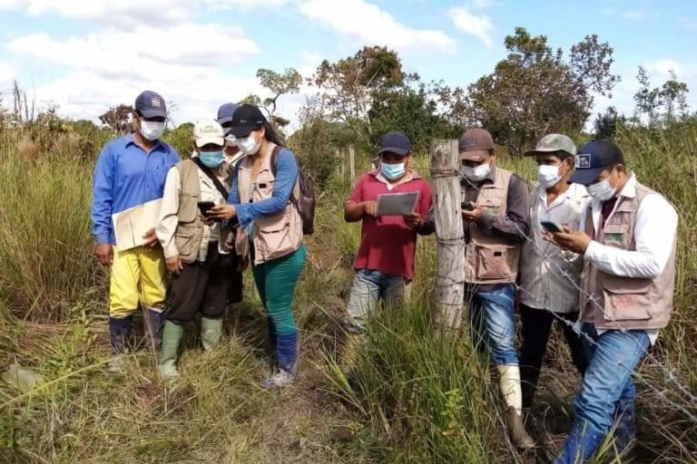
In the event of a fire, the monitors use cellphones with GPS and apps to gather precise geographic information.

Victoria Aguilera, a geographer from the CPTA research team, says that when a satellite alert points to a potentially affected area, the monitors receive the geographical information and visit it to check whether there’s a fire. “They collect the coordinates via apps and enter a description of the problem, and the data is uploaded to the cloud as soon as the phone has an internet connection. The information arrives almost in real time,” she says.
Aguilera says that when they set out to create teams of monitors, it was the community members themselves who put forward representatives to be trained in using the technological tools. “We were surprised by the great interest people showed,” Aguilera says.
The teams are made up of young people from 16 years old through to older members above the age of 50. “Of these, at least 30% are women, although in some communities the figure is as high as 50%,” Aguilera says.

“The teams needed training in how to use these tools for territorial monitoring,” Aguilera says. “Young people handle cellphones very well, but at the same time they need the perspective of those who know the land.”
In addition to being alert to fires, the monitors also keep an eye on water resources. “What worries me most is the water problem,” community leader Vaca Diez says. “The natural lagoons are drying up due to issues such as climate change and burning by Mennonite colonies.”

The monitors’ work isn’t easy. Vaca Diez says that when she needs to check on the lagoons, she has to get up early to get things ready at home for her three children. Then, after a long day of hiking, she returns home to once again take care of her family.
Keeping an eye on mining and oil activities also falls within the monitors’ remit, as well as threats of encroachment — illegal trespassing into their territories by outsiders seeking to expand their farmland.
Beyond monitoring
“Socioenvironmental monitors generate their own data, and are aware of changes going on within their territories,” says sociologist Arturo Revollo from CEJIS’s Santa Cruz Indigenous territorial management regional team.

Revollo says it’s vital for community members to manage such information, as this is the only way they can make informed decisions about the future of their territories.
The idea behind monitoring, Revollo says, is for Indigenous populations to understand, and have control over, the issues that put their forests at risk. “This is essential for decision-making and good territorial management,” he says.
For this reason, the monitors are trained to understand the laws, regulations, treaties, agreements, and, more generally, Bolivian and international rules that allow them to make the most appropriate decisions and avoid environmental damage in their communities.

“I became a monitor following a dispute, when miners arrived in my community without consultation, as if they were subjugating us,” says José Cuasace, a monitor in the Totoca community, in the Lomerío territory. “It was then that I decided that I wanted to be a part of this team of monitors.”
They began by learning about mining law and Bolivia’s Constitution, Cuasace says, as well as visiting areas in the territory where miners were operating illegally. They were then trained to use GPS technology and cellphones to locate areas based on coordinates.
“For two years we have been watching with concern how our territory has been set alight,” Cuasace says. “For this reason, we have now been trained as volunteer firefighters, and we continue to fight against this threat.”

The monitors are part of CICOL, the union of Indigenous communities in Lomerío. “We are the socioenvironmental operational arm of our organization,” Cuasace says.
Organizing themselves in this way has already reaped rewards, he adds. “We have managed to survey most of our territory,” as well as having stopped threats. “Before, there was a lot of encroachment and timber trafficking. Now we know our territorial boundaries and we try to ward off disputes. It is an incredible experience.”
Banner image of socioenvironmental monitors analyzing their territory, courtesy of CEJIS.
This story was reported by Mongabay’s Latam team and first published here on our Latam site on Aug. 18, 2021.