Soggy Autumn in the Pacific Northwest
Dec 9, 2021
As meteorological autumn came to an end in 2021, parts of western Washington and southern British Columbia were still saturated from the barrage of rainstorms that repeatedly soaked the area. The moisture is especially evident in the region’s soils, which had little time to dry between storms.
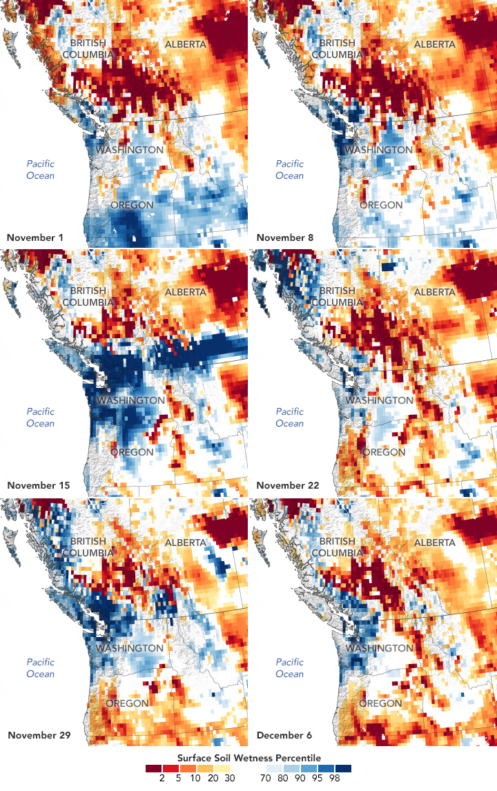
These maps show a weekly “snapshot” of surface soil moisture from November 1 to December 6, 2021, as measured by the Gravity Recovery and Climate Experiment Follow-On (GRACE-FO) satellites. The colors depict the wetness percentile; that is, how the soil moisture on those days compared to long-term records (1948-2012). Blue areas have more abundant water than usual, and orange and red areas have less.
These maps represent the moisture in the top 2 centimeters (0.8 inches) of soil. Moisture in this layer—and slightly deeper in the root zone—can fluctuate significantly over short periods of time. Unlike deep groundwater aquifers, surface layer soils are quickly replenished by rainfall. Notice the vast expanse of wetter-than-usual (dark blue) soils on November 15, the third day of a potent storm. The narrow bands of moisture missed some locations, especially inland areas, where surface soils stayed drier than usual (orange and red) throughout the month.
Surface layer soils are also the first to dry out. Notice that by November 22, parts of western Washington and southern British Columbia do not look quite as wet. But the parade of storms kept coming, with three atmospheric rivers pouring into the region within a week in late November.
Soils generally stayed soaked throughout the record-wet season. Ground-based observers in Seattle recorded about 48 centimeters (19 inches) of rain from September through November—the largest amount since records began in 1945. Just over 25 centimeters (10 inches) fell in November alone, raining on all but five days of the month. Farther north, a record 37.01 centimeters (14.57 inches) fell in Bellingham, Washington. In British Columbia, the cities of Vancouver, Victoria, Nanaimo, and Abbotsford all broke records for September-November rainfall. Some areas in B.C. are still cleaning up and rebuilding after the storms and floods devastated homes, roadways, and farmland.
When soils are already saturated, additional rainfall can pose an even higher risk for flooding and mudslides. Looking ahead, a hazards outlook issued on December 7 by the Climate Prediction Center of the U.S. National Weather Service noted: “Following a wet November when precipitation averaged 150 to 200 percent of normal, many river levels across northwest Washington are running above the 95th percentile. Due to the ongoing antecedent wetness and heavy rainfall (3 to 5 inches) forecast during the next week, a flooding possible hazard is posted for northwest Washington. This flooding risk may persist throughout week 2, since above-normal precipitation is favored to continue in this region.”
NASA Earth Observatory image by Lauren Dauphin, using GRACE data from the National Drought Mitigation Center. Story by Kathryn Hansen.
