Tracking the Invisible Movement of Water
Feb 2, 2024
Today’s story was adapted from an article published on science.nasa.gov.
As the world looks for sustainable solutions, a system tapping into NASA satellite data for water management has passed a critical test.
Called OpenET, the system uses an ensemble of six satellite-driven models that harness publicly available data from the Landsat program to calculate evapotranspiration (ET)—the movement of water vapor from soil and plant leaves into the atmosphere. OpenET does this on a field-level scale that is greatly improving the way farmers, ranchers, and water resource managers steward one of Earth’s most precious resources.
Researchers recently conducted a large-scale analysis of how well OpenET is tracking evapotranspiration over crops and natural landscapes. The team compared OpenET data with measurements from 152 sites with ground-based instruments across the United States. In agricultural areas, OpenET calculated evapotranspiration with high accuracy, especially for annual crops such as wheat, corn, soy, and rice.
“I was pleasantly surprised by the results,” said John Volk, lead author of the study and assistant research scientist and software engineer at the Desert Research Institute in Reno, Nevada. “The accuracy in croplands was quite strong, particularly in western arid regions, which are important areas for agriculture and have water sustainability challenges.”
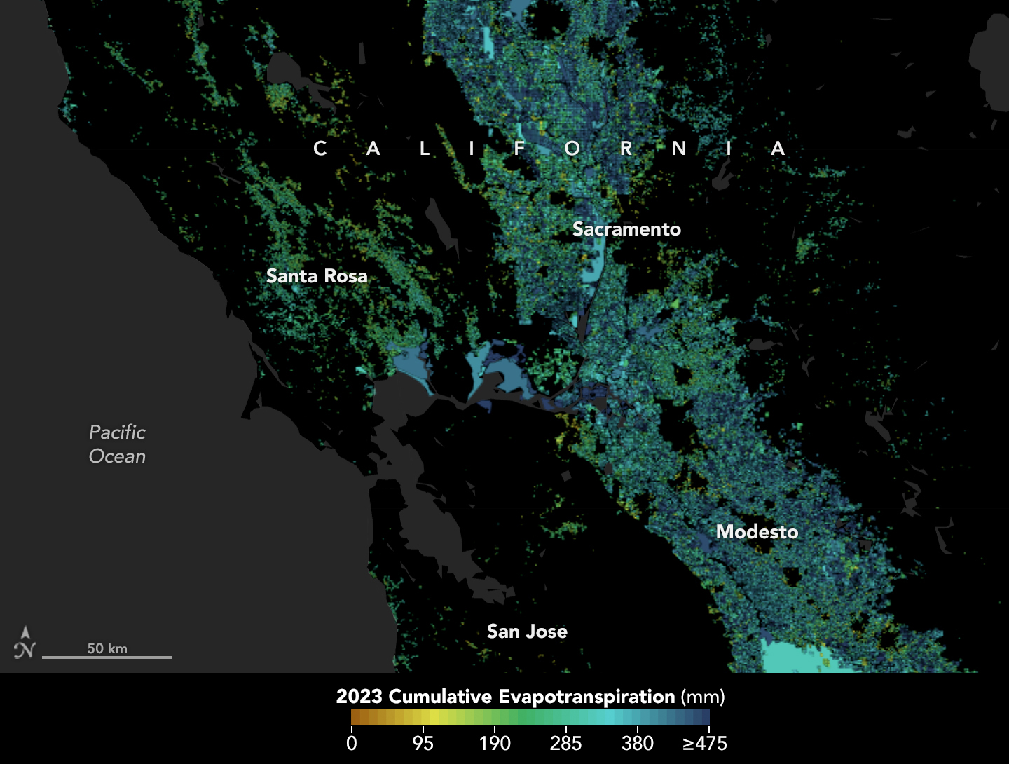
That’s welcome news for regions where OpenET data is already being put to work. In Northern California’s Sacramento-San Joaquin Delta, water resource managers are using OpenET to help farmers comply with state rules requiring them to report aspects of their water use.
The map at the top of this page is derived from the OpenET data explorer. It shows cumulative evapotranspiration for 2023 in California’s Central Valley, including the Sacramento-San Joaquin Delta. Colors represent the total evapotranspiration as the equivalent depth of water in millimeters. Dark blue areas are where evapotranspiration is the highest—up to at least 475 millimeters (18.7 inches) over the course of the year. These regions usually have dense vegetation or irrigated fields.
While many people are familiar with what one inch of rainfall means, few stop to think about one inch of evapotranspiration returning to the atmosphere, said Forrest Melton, the OpenET project scientist at NASA’s Ames Research Center in California’s Silicon Valley. “OpenET is working to make the unseen process of evapotranspiration as easy to track as checking the amount of rainfall in the daily weather forecast.”
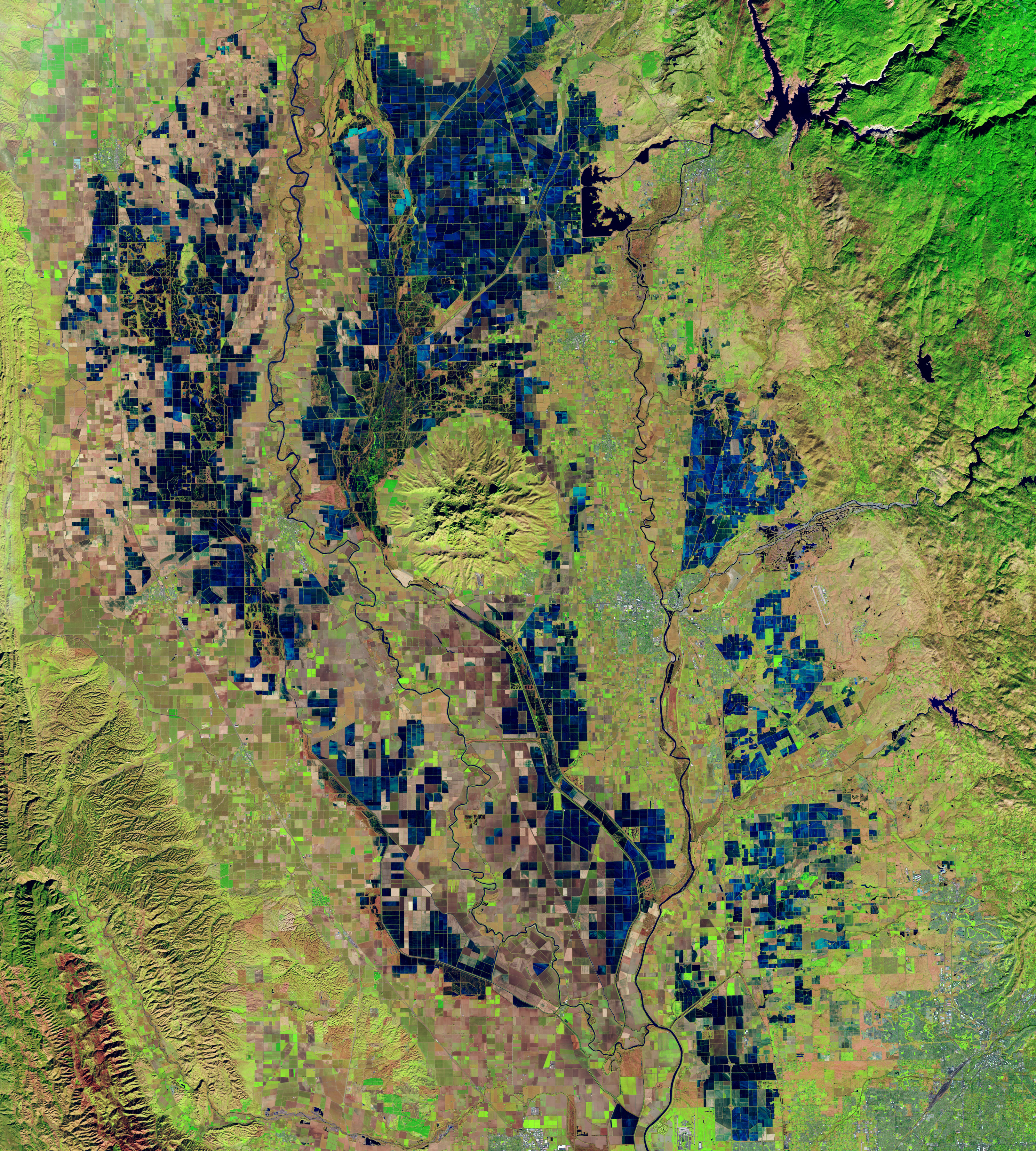
OpenET’s primary observations come from the Landsat 8 and 9 satellites, a partnership between NASA and the U.S. Geological Survey. The second image above, acquired with the OLI (Operational Land Imager) on Landsat 8, highlights a patchwork of flooded rice fields along the Sacramento and Feather rivers on December 26, 2018. In this false-color image, inundated fields appear dark blue and vegetation is bright green.
The Landsat satellites also provide data on land surface temperatures and the greenness of plants, among other things. Cooler land surface temperatures over areas with healthier, denser vegetation, for example, usually indicate higher levels of transpiration. Those data are then fed into models to calculate evapotranspiration at high resolution—about a quarter of an acre for each image pixel.
The new analysis of OpenET’s performance, published January 15 in Nature Water, shows that for agricultural lands, OpenET data for monthly, growing season, and annual timescales had an average error rate of about 10-20 percent. Lindsay Kammeier, a senior engineer with the California State Water Board in Sacramento and not involved in the study, said the result “gives us more confidence that these numbers are accurate, and that OpenET is continually improving over time.”
Maps by NASA Earth Observatory, using data provided by the OpenET team at NASA and the Desert Research Institute, available at openetdata.org and described in research by Volk, J.M. et al. Landsat image by Lauren Dauphin using data from the U.S. Geological Survey. The OpenET consortium includes NASA, USGS, and the U.S. Department of Agriculture working with the Desert Research Institute and nearly a dozen other universities, Environmental Defense Fund, and Google Earth Engine. Story by Emily DeMarco (NASA Earth Science Division) adapted for Earth Observatory by Kathryn Hansen.